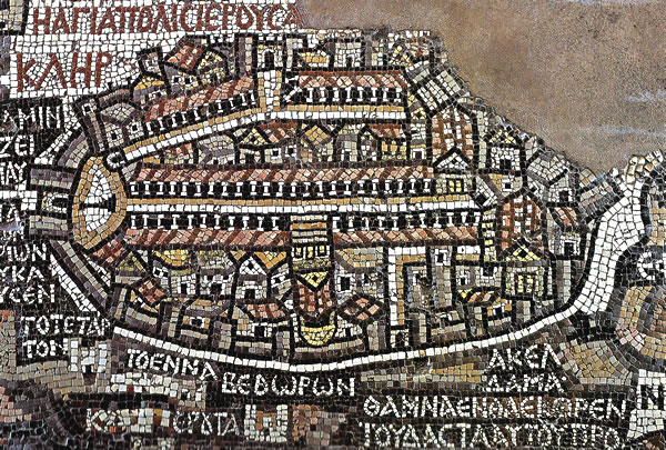
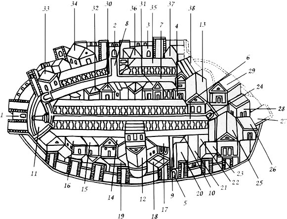
| 1. Damascus Gate. |
13. Nea Church. |
27. Clergy House of Mount Zion. |
| 2. St.Stephen's Gate. |
14. Palace of the Patriarch. |
28. Baths above Siloam Pool. |
| 3. Golden Gate. |
15. Clergy House of the Patriarch. |
29. Church near Siloam Pool. |
| 4. Nea Gate, perhaps the Dung Gate. |
16. Hospital. |
30. Probably the Church of St.Sophia. |
| 5. Jaffa Gate. |
17. Forum. |
31. Monastery of St.Cosmas and St.Damianus. |
| 6. Cardo Maximus. |
18. Baptistry of the Church of the Holy Sepulchre. |
32. Public Baths. |
| 7. Roads of the Tyropoeon Valley. |
19. Monastery of the Spudaei. |
33. Palace of the empress Eudocia. |
| 8. Street leading to St.Stephen's Gate. |
20. Tower of David. |
34. Church of the Sheep Pool. |
| 9. Decumanus, leading from the Jaffa Gate. Today this is most probably David Street.. |
21, 22, 23. Monasteries. |
35. Temple Area (indicated by a black line of cubes). |
| 10. Street leading to Mount Zion. |
24. Gate leading to Mount Zion. |
36. Ruins of the Antonia Fortress. |
| 11. Plaza in front of the Damascus Gate with a column mounted by a statue or a cross. |
25. Church on Mount Zion. |
37. Church of St.James. |
| 12. Church of the Holy Sepulchre. |
26. Diaconicon of Mount Zion. |
38. Some scholars think that this was the Western or Wailing Wall. It is more likely the ruins of the wide staircase in front of the southern wall of the Temple. |